Site Markers: Signs & Flags
Identifying Water Trail Access Sites
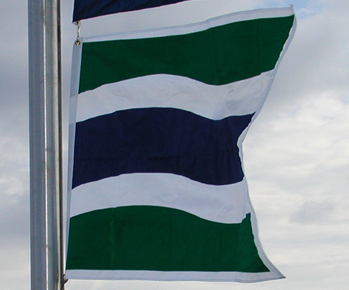
You may find that many–but not all–of the Designated Access Sites display Water Trail signs, and a few are flying Water Trail flags (as pictured below). These aids to finding a site can be helpful in directing you to a preferred launch or takeout at a site.

To find an access site using the Hudson River Greenway Water Trail Map, go to the
Water Trail Map. Then click on any access site and within its pop-up box, click on "More Info."
For a more complete description of the Hudson River Greenway Water Trail see teh seventh edition of the Hudson River Water Trail Guide available for purchase.
The Hudson River Valley Greenway has provided interpretive Water Trail kiosks at about a dozen access sites. Locations of these kiosks are:
The Greenway has also provided 65 lockable kayak racks with gear storage boxes for the temporary storage of kayaks. The 65 racks are located at 33 sites. A complete list and directions for their use can be found on the Kayak Storage Racks page.
read more...
For a more complete description of the Hudson River Greenway Water Trail see teh seventh edition of the Hudson River Water Trail Guide available for purchase.
 More Helpful Information
for Water Trail Users
The Hudson River Valley Greenway has provided interpretive Water Trail kiosks at about a dozen access sites. Locations of these kiosks are:
- Battery Park, Waterford, Saratoga County
- Peebles Island State Park, Waterford, Saratoga County
- Henry Hudson Park, Bethlehem, Albany County
- Schodack Islands State Park, Schodack, Rensselaer County
- Stockport Landing, Stockport, Columbia County
- State Boat Launch, Athens, Greene County
- Charles Rider Park, Ulster, Ulster County
- Reese Park, Wappingers, Dutchess County
- Kowawese Unique Area, New Windsor, Orange County
- Little Stony Point, Philipstown, Putnam County
- Haverstraw Bay county Park, Haverstraw, Rockland County
- Croton Landing Park, Croton-on-Hudson, Westchester County
The Greenway has also provided 65 lockable kayak racks with gear storage boxes for the temporary storage of kayaks. The 65 racks are located at 33 sites. A complete list and directions for their use can be found on the Kayak Storage Racks page.


 Planning your paddling trip on the Water Trail can be made easier if you have our printed, water and tear-resistant